Friday, November 27, 2015

Mission San Luis Obispo de Tolosa

Gaspar de Portola, Governor of Los Californias, and Father Juan Crespi attempted to reach Monterey Bay by land in 1769. Along the way, the party camped in a lovely valley where they were amazed to find so many bears. They gave it the nickname La Canada de los Osos (The Canyon of the Bears). Years later, when food supplies were running low, Father Serra remembered the valley and sent hunters there. The successful hunt and further investigation convinced Serra that the area would make the perfect site for a mission and so work on it began. In 1792, Serra christened the mission San Luis Obispo de Tolosa in honor of Saint Louise, Bishop of Toulouse, France. 
    The early years were not always peaceful for the mission. While many of the local Indians were friendly, there were a few were not.  On three occasions, they set fire to the mission’s thatched roof. In answer to this, the padres developed a red, fire-resistant, clay tile, which proved to be a good deterrent. The tiles were such a success that all the missions began using the new formula for roofing material.
    None of Alta California’s missions were ever fully self-sufficient; consequently they received some financial support from Spain, albeit modest. The Mexican War of Independence in 1810 changed all that. Gradually, over time, Spain sent fewer funds, which caused major financial problems for most of the missions. Spain also forced the missions to send food and clothing to the army. The demand was a heavy burden on Mission San Luis Obispo, but it was able to not only meet the demand, but also continue its building program. By 1820, the mission had finished the construction of its quadrangle. And then circumstances worsen.
    By 1835, Mexico had been an independent nation for fourteen years. During that time the Mexican government secularized Mission San Luis Obispo, which meant the padres no longer managed it. Pio Pico, Alta California’s governor, sold the mission's buildings, all except the church for $510. The buildings were then used for a variety of civic and military uses.
    During the Bear Flag Revolt, John C. Fremont and his "California Battalion" occupied the mission and used it as a base of operations. It was later used as the first courthouse and jail in San Luis Obispo County, California. The mission was eventually returned to the Catholic Church.
    In the early days of statehood, the citizens of San Luis Obispo lived in fear of the many bandits that roamed at will throughout the area. In 1853, the notorious bandit Joaquin Murietta, “the Robin Hood of El Dorado,” and his men terrorized the town, literally taking it over and occupying it for several days. They camped in the mission’s garden. Later that same year the newly formed California State Rangers brought about an end to Murietta’s gang.
   
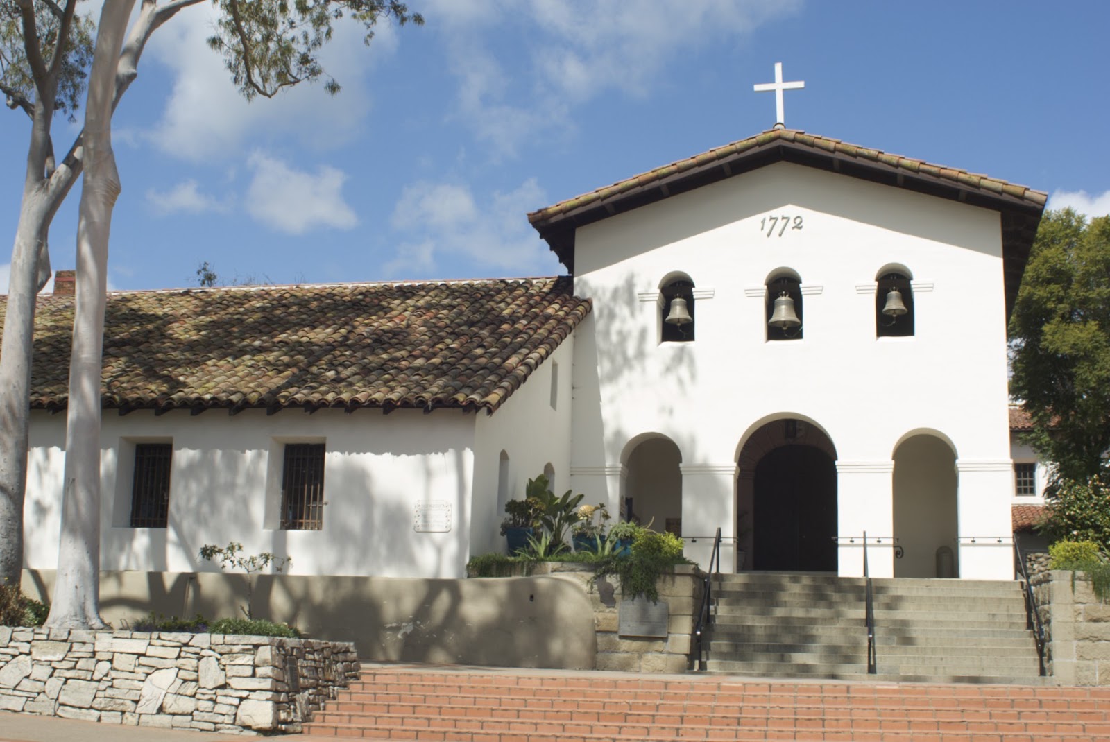
 The mission’s buildings have design features that are unique among the twenty-one missions. There are three bells hanging in three arched openings above the church entrance. The vestibule, sits at a right angle to the main part of the church (nave). It's almost equal in size and shape to the nave. The convento colonnade has square openings and round pillars, a style not used in any other mission.
    Even though Mission San Luis Obispo went through many changes during its history, it remained in its original location, unlike many of the other missions. Today, the mission is in the center of a thriving city that grew up around it and functions as a Roman Catholic parish church in the Diocese of Monterey. San Luis Obispo proudly calls itself, "The City with a Mission."

NOTE: Los Californias = Baja California & Alta California.  The convento is where the friars live.  Friars differ from monks in that friars are called to a life of poverty in service to a community, while monks cloister themselves away from society.  Friar is a corruption of the French word frere meaning brother.


The photographs below show places where a section of a wall has been purposely exposed to show the building materials. On the left is a portion of a wall and on the right is a section of an adobe wall.

Monday, October 26, 2015

Cave Lake

Nevada’s Cave Lake is a very popular state park for people who love outdoor recreation. The 32-acre reservoir sits at 7,300
feet and has an average depth of 25 feet and 60 feet at the deepest. The last time I was there it was in early March and the lake was still frozen over. I arrived too late to see the annual White Pine Fire and Ice Show, which features ice and snow sculpturing. But there were ice fishermen hard at work, plying the water for trout. I didn't see any of them catch any fish, but they seemed to be pretty content anyway. As of 2006, Cave Lake holds the record for the largest German brown trout, weighing more than twenty-seven pounds. If you like crayfish, fresh water cousins to lobsters, well there’s a large population of them that’s pretty easy to spot along the shoreline.
    Some people consider Cave Lake State Park to be the most beautifully situated parks in Nevada. Richard Moreno, author of Backyard Traveler says, “The dark emerald lake is situated in a scenic niche in the mountains, surrounded by forests of pinyon and juniper. Above the lake is a small yawning cave—the namesake of the lake—and ridges of rough, crumbling granite peaks weathered by countless centuries of icy winters and hot summers.”
    In 2012 Recreational Boating & Fishing Foundation, a national organization, invited Facebook subscribers to help determine the top eight natural "waterparks" or state parks, for boating and fishing in America. There were 24 nominees and after eight weeks of voting Cave Lake State Park wound up as one of the top eight for fishing, boating and family fun.
    There's a pretty good campground adjacent to the lake. It offers the usual camping sites. If you decide not to pitch a tent or park your RV, you could stay in one of the yurts. I just might do that some day.

Cave Lake State Park is located in White Pine County, Nevada 15 miles southeast of Ely.

Note: Nomads in the steppes (grassland plains) of Central Asia traditionally built yurts as dwellings. They were well insulated, weatherproofed and above all portable. The first written evidence of them dates back to 484 BC when the Scythians, a horse riding-nomadic nation used them. Yurts were designed in such a way that they could be dismantled and then loaded onto camel or yaks and transported to the next location. It took an experienced nomad about two hours to build one. The yurt at Cave Lake has a wood lattice frame, plywood floor and canvas wall and ceiling.

Wednesday, October 14, 2015

Alabama Hills, California

Return with me now to the thrilling days of yesteryear when out of the West rode: Tom Mix, Hopalong Cassidy, Roy Rogers and Dale Evans, Gene Autry, the Durango Kid and many others too numerous to mention. In each of their movies they chased the bad guys past rock formations that became legendary in the annals of western movie making. These potato-shaped, weathered granite boulders are the Alabama Hills. They sit under the shadow of the Sierra just as they have for millions of years. In the early days of movie making, Hollywood directors and producers discovered these rocks and made them famous. Over 400 movies and about a dozen TV shows have been produced in this location.
    When Gunga Din (Sam Jaffe) blew his bugle to warn the regiment of an ambush in what was suppose to be the Khyber Pass, it was really Alabama Hills
    When the gladiator, Russel Crowe, rode his horse in what was suppose to be Spain, it was really Alabama Hills.
    When rangers were ambushed and all except one survived, later known as the Lone Ranger, it was really Alabama Hills.
    When Major Kearny (Gary Cooper) hunted for the gang of jayhawkers and Confederate soldiers who stole Union army horses, it was really Alabama Hills.
    When the star-studded cast of How the West Was Won drove their wagons through mountain country, it was Alabama Hills.
    And when I looked for an interesting spot to expose some film, it was, you guess it, Alabama Hills.
    If or when you decide to visit this hallow ground of movie nostalgia, make sure you first stop in Lone Pine and investigate the Beverly and Jim Rogers Museum. They have a collection of old movie memorabilia that covers all the movies ever produced in the area. The collection includes costumes, cars, props, posters and a whole bunch of fun stuff. While you there glom onto the Self Guided Tour of Movie Road and you’ll be set for a fun trip. Failing that, Google it and see what you missed.

                        Note: Mount Whitney is just right of center at the top of the photograph.

Wednesday, October 7, 2015

Sand Mountain


About twenty miles east of Fallon on US-50, The Loneliest Road in America, there’s a very large dune called appropriately Sand Mountain. The dune is two miles long and stands 600 feet high. Where did all that sand come from? This giant sand pile sits at the edge of prehistoric Lake Lahontan. When that ancient lake dried up, about 9,000 years ago, it left behind sand. The wind piled most of that sand in one spot.
    Sand Mountain is a singing sand dune. Here’s why… Dunes are capable of producing sound; the sound has been described as either singing, whistling or barking. In order for there to be any sound, certain conditions must exist: the sand grains must be round and under a millimeter in size, the sand must contain silica, and the air must have a certain humidity. If all of those conditions are met, then the sound can be caused by the wind passing over the surface, or simply walking on the sand.
    Today, Sand Mountain is a recreational area managed by the Bureau of Land Management. It’s open to off-highway vehicles. But those ATVs have to be careful, not only for safety reasons, but also because the area is home to the Sand Mountain Blue Butterfly and it’s their only home, because unlike other butterflies, the Mountain Blue doesn’t migrate. The larva will only eat Kearney buckwheat, which grows on the dune. The BLM has closed several off-road trails in order to protect the species. There are strict rules and users must pay either a weekly or yearly fee.

    You can go there to test your dune buggy driving skills, observe butterflies, and/or walk the dune listening for singing silica. Whatever the reason, it’s still worth a stop just to see up close one colossal pile of sand.

Monday, October 13, 2014

Paradise Valley, Nevada

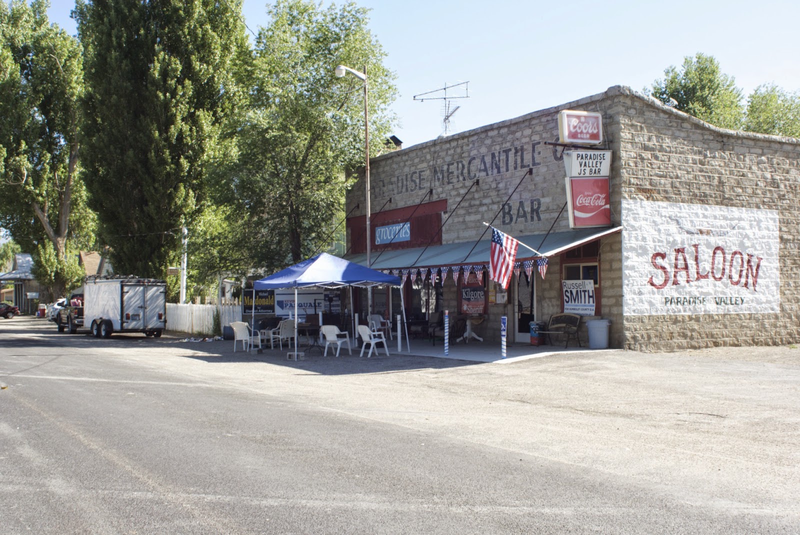
The old mercantile is long closed.

This is the heart of downtown Paradise Valley on a typically quiet day.
North of Winnemucca, Nevada you can find paradise, Paradise Valley that is. With a name like that, there’s a lot to live up to. I haven’t spent enough time there to say yea or nay, but I do know it’s a very peaceful place. And that is definitely on my list of requirements for a paradise. It’s a sleepy, backwater hamlet that I suspect few outside of Nevada know about and I have a feeling the people who live there like it that way.
    Besides farming and ranching, its other claim to fame is that Edna Purviance (Purr VYE ance) was born there. Her name probably doesn’t ring a bell. That’s because you’d have to be a silent movie aficionado in order to recognize it. She appeared in 33 of Charlie Chapin’s productions, including the trail blazing “The Kid” that made Jackie Coogan a major child star and was the very first feature length film to combine comedy and drama.
A three-story hotel once stood on this site. All that
is left is its red water tower. That's the Santa Rosa

snowcapped mountain range in the background.
    Fifty-five years before Edna was born a lot had already happened in the valley. The founder of the community, a man by the name of W.M. Gregg was searching for a mining claim in the nearby Santa Rosa Mountains in the mid 1860s, but he changed his mind when he realized that all the land in the valley at the base of the mountains was rich, fertile soil. So he gave up on mining, traded in his shovel and bought a plow and went into the hay business. Others, however, made a number of mining strikes in them thar hills and they really helped Paradise City to become prosperous.
This architecture of this church 
fits perfectly with the surroundings.
    Paradise Valley wasn’t always so peaceful. Soon after Gregg founded Paradise City and the mines opened, trouble with the local Indians began.  There were several bands in the area made up of Paiute, Shosone and Bannock. They tried to stop the white man from plowing up the land they considered to be theirs and to bring to an end the contamination of streams by the mining operations. It was never a full fledge war, but there were some pretty bad skirmishes. The military presence at newly established Fort Winfield Scott, located near the valley, quickly ended any further threats. With the threat of attacks gone farmers, ranchers and miners could continue their work without fear.
    After extracting close to $3,000,000 in silver, the mines petered out and the town’s population took a nosedive. It quietly went to sleep and Paradise City never really regained its former prosperity. The old saloon closed its doors, as did most of the other businesses. Paradise City was on the verge of becoming a ghost town, but the valley would soon come alive again, but this time with cattle ranching and farming. Somewhere along the way it acquired a slight change in its name, adopting the name of the valley.
This is Nevada's famous Micca House. 

    There’s a story that has circulated for years concerning a lost mine. It’s sometimes hard to tell fact from fiction, but nevertheless this is what supposedly happened in the Santa Rosa Mountains at a peak called Buckskin. It seems two Idaho prospectors were poking around and somewhere on the southern slopes, near a small spring, they came across an outcrop of “curious strange-looking” ore. The two were not impressed by what they found, but just to be on the safe side they had an ore sample assayed. And sure enough the ore was exceedingly rich. The prospectors raced back to where they thought they had found the ore. They searched and searched, but never found that small spring. So is the rich strike still up there? Who knows, could be?
The old weathered barn is photographed as often asthe Micca House. It just hasn't 
been published as often.
    It’s difficult to establish the exact date when the Micca House first opened its doors. It was built in stages beginning with an adobe section in 1871. Over the years the building was added onto. It then housed shops, small businesses, apartments, a restaurant, a barbershop and a saloon. I guess you could say it was probably Nevada’s first mall. In 1910 the flexible building contained the offices of the Justice of the Peace, two physicians and the CCC. I’ve heard the building’s name pronounced two ways, so I’m not sure whether it’s MY-cuh, or MIC-cuh. The Micca Saloon closed long ago. however it continues to be a popular subject and I can see why. Its image appears in many Nevada oriented ads and magazines.
    Apparently the residents don’t care to be referred to as a living ghost town, even though there are some wonderful abandoned buildings from the time when mining was the order of business. Those mines were replaced with fat cows grazing on rich grass, alongside acres planted in alfalfa. There’s even a grape vineyard. The residents would argue that Paradise Valley is very much alive and that the only ghosts might be found over in the Micca House.


R