Tuesday, March 25, 2014

Austin, Nevada, a lonely town on the loneliest road

On one memorable trip, I headed to Austin and instead of starting out in Fallon, I began in Battle Mountain, motoring south through the Reese River Valley, along State Route 305, another lonely Nevada byway. According to the web, the valley has only one person per square mile. I believe it; I didn’t see a single person, but there were quite a few cattle grazing among the sage. It’s a pleasant, peaceful 88-mile drive.
    If you like having the feeling of being alone in the world and still have a few people around you, then Austen is the place for you. It’s one of Nevada’s most isolated towns, but it’s still easy to find. One author put it this way, “'Like an Easter egg hidden on a billiard table, Austin is hard not to find. All motorists traversing U.S. Highway 50, the 'loneliest-road-in-America,' eventually have to drive down the 'main street' of Austin, whether they want to or not.'” 
    History tells us that Austin began in 1862 when Will Talcott’s pony express horse supposedly kicked over a rock laden with silver and gold.
The news got out and the rush was on. It became the biggest stampede since the Comstock Lode strike in 1859. In less than a year 10,000 people populated the Reese River Mining District and eventually Austin was in the heart of it. By the time the ore played out close to $50,000,000 worth of gold and silver had come out the mines.
    I’ve never been in Austin in June. Some day I want to go there to check the accuracy of an article I read on the town’s name. According to the author “there’s hardly a place in town that isn’t graced with yellow rose bushes and they undoubtedly come from Texas,” and Austin claims to be named after Austin, Texas. I put two and two together and came up with this possibility: “The Yellow Rose of Texas,” a song written in 1858 may have been the inspiration for all the roses. Perhaps one of the founding fathers was from Texas? Could be. I’ve tried to find out for sure, but I haven’t yet...still looking.
    Today, there are only 340 hardly souls living in Austin. The last time I was there a couple gas stations, three motels, four churches and a hardware store were still in business. The nearest supermarkets and shopping mall are over a hundred miles away, so if you live in Austin, you better be well organized, know how to take care of yourself, and like long drives.
   
There’s a story that has circulated for years about the Reese River. Seems back in the early days of Austin, a grand scheme was hatched which involved using the river to transport loads of ore from Austin north to the mills in Battle Mountain, which would take advantage of the fact that the river, unlike most rivers, flows south to north. So The Reese River Navigation Company (RRNC) was established and stock was sold to investors who had never seen the river, except for a line on a map. But it would have been impossible then as it is now to float anything larger then an inner tube down the Reese and even that would be problematic. For much of the year the river is a series of puddles connected together by land, so it turns out it was all a hoax. The story first appeared in Nevada newspapers in 1946. There’s no evidence that the RRNC ever existed or that stock was ever sold. People nevertheless believe the story, because it continues to be repeated. 
    I had breakfast at the International Cafe, not bad.
The building is part metal, part wood, which is typical of the architecture during those early mining days. They used whatever was available. The food may not be sensational, the service may not be the greatest, but the old building and it ambiance is well worth a visit.
    When I found out that there was a castle nearby, I immediately thought of knights and moats. Well, it turned out to be not like any castle I’d ever seen. This castle was patterned after one in Italy. Around 1896 a man named Anson P. Stokes built what became Stokes Castle. It’s basically a square three-story tower made of hand hewn granite stones, cemented together with rock wedging and clay mortar. Stokes was a mine developer, railroad magnate and a banker, probably a man with deep pockets. Stokes wanted a summer home with a view of the Reese River Valley.
The design had a kitchen and dining room on the first floor, a living room on the second floor, sleeping quarters on the third floor and a battlement terrace on the roof. Each floor had a fireplace and plate glass windows. The two top floors each had balconies. Stokes and his family abandoned their summer home after only spending a short time there. They sold all of their holdings and left, never to return. Stokes Castle never saw another owner. In 2003, it was placed on the National Register of Historic Places.
    Austin's oldest church is also the oldest Catholic Church in Nevada. St. Augustine was constructed in 1868. Ringing the church bells, located in the 75-foot tower, calls for the bell ringer to go into the men’s restroom. That's where the rope is located. Odd but true.

    OK, so Austin isn’t what you call a destination, but nevertheless as long as you have to pass through it you might as well stop and have a look around. Besides you’ll probably be either out of gas or hungry by the time you get there. Never can tell what you might find.


k

Monday, February 10, 2014

Wendover, A Town With a Split Personality

Ah Wendover, what an enchanting place-----not! It’s a remote watering hole on the border of Nevada and Utah at the edge of the great Bonneville Salt Flats. On the Nevada side (West Wendover) there’re mostly casinos and some commercial enterprises. On the Utah side there’re some run down houses mixed in with a couple nicer ones, some more commercial enterprises, funk, junk and rust, and a then there’s the very big ancient playa off to the east. There are perhaps three reasons to stop: get gas, have a bite to eat, or play a game of chance. But if you're like I am, you'll have a fourth reason; you're curious. I stopped and found some things that made the place interesting.
    #1 ... If you had been standing in that desert about 16,000 years ago, you’d have been 1,000 feet under water. How could that be? Well, over a 3,000,000-year period the
climate of North America went from wet to dry several times. Glaciers formed and then receded leaving behind pluvial lakes, great bodies of landlocked water that sit in natural basins. In the southwestern United State several of these prehistoric lakes were the result of the wet periods. One such lake was named Bonneville. It formed about 32,000 years ago and covered 19,800 square miles. Over time, as the climate changed to dry, Lake Bonneville slowly disappeared, leaving behinds salt. Today, the Great Salt Lake and the Bonneville Salt Flats are reminders of the ancient lake.
    #2 ... In 1907, a trio of men wanted to find out if they could drive an automobile across the salt flats. They succeeded and that opened the door. But it wasn’t until the mid 1920’s that a highway (US 40) was built across it. Much later the route was improved and it became Interstate 80. Back in 1924, entrepreneur William “Bill” Smith seized the moment and with $500 he had saved and a partner, built a gas station and garage to service all the travelers brave enough to the cross the salt flats. Smith hooked up a light bulb to the top of a flagpole. This beacon burned brightly 24/7 and as a result, Wendover became known as “the light in the desert.” He later added a cafĂ© and a few bungalows. In 1931, they received one of the first gambling licenses issued in Nevada and so began the Wendover Hotel and Casino. All went well until Smith and his partner’s family had a falling out. They agreed to flip a silver dollar, winner take all. Bill Smith won. Years later the light bulb was replaced with a waving neon lit statue of the “World’s Tallest Cowboy,” Wendover Will. He has been welcoming travelers since 1952. He’s 63’ tall and includes 1,1184’ of neon tubing. Several years ago he was given a new home on the old highway into town. 
    #3 ... The Stealth Gallery located in the historic and fast deteriorating Wendover Air Force Base is one of the funkiest, if not the funkiest galleries in all of gallerydom. Picture a broken-down, single story military barracks hidden amongst similar ghostly buildings inside a compound marked by a chain-linked fence. The gallery is not easy to find because it hides behind the other abandoned barracks and it hides well. But after a couple false positives I found it and once I entered the door's lock combination (1,2 for any of you incline to wander there) I went inside. Nothing had changed from my last visit.  There were the same land use pictures and information and the same rather ugly pictures. I think the high water mark came when friend Richard Menzies had his show there. He brought a lot of class to the place. Unfortunately it's been downhill ever since.
    #4 ... Wendover Field, a WWII Air Force base is slowly decaying. But a small band of devoted enthusiasts are hard at work raising funds to restore portions. There's a very nice museum, which depicts the base's important contributions to the war effort. It became the largest Air Force base in the world. During WWII it provided training for B-17 and B-29 flight crews. Once they reached reasonable skill levels, they took off, and either flew to Germany to drop bombs on Hitler or off to Japan to do the same to Tojo. No less than the famous Enola Gay was based here. This is where the crew trained. Col Tibbets, its pilot, chose this spot because of the isolation. Big Boy and Fat Man (Atomic bombs) were tested out there in the great expansive desert. Kaboom! and a mushroom cloud!
    The air base is now a civilian airport with what amounts to an unusually long runway. It has been turned over to Wendover and was given a new name, Decker Field. Buildings have been leased for storage, but the hanger that housed the Enola Gay, the B-29 Superfortress that was used to drop the atomic bombs, remains much as it once was. A devoted group of people is in the process of restoring some of the old base as a lasting tribute to its historic value.

    Wendover is a town caught between two states, Nevada and Utah, but it’s not only the border that separates. West Wendover, Nevada is prosperous; Wendover, Utah is not. West Wendover has gambling; Wendover, Utah does not. The only place where they seem to come together is time; both are in the Mountain Time Zone. For years Utah and Nevada have endorsed the idea of only one Wendover. The plan called for the eastern part to be annexed into Nevada, but Wendover’s town council voted against it, so until such time as there is annexation, Wendover will remain a place with a split personality.


k

Saturday, January 4, 2014

Angel Lake

Angel Lake seems like it should be somewhere else, but nevertheless there it is, a lovely alpine mountain lake not far from Wells out in the high Nevada desert. I read about the lake in a tourist pamphlet I found in the Wells chamber of commerce. The pamphlet said it’s a popular recreational area. Well, it looked too good to pass up, so naturally I had to go see for myself. Wow, what a surprise! It sits at 8,378’ elevation tucked into the summit of the East Humboldt Range and is surrounded on three sides by granite cliffs, giving it the look of a Sierra lake. Greys Peak at 10,674’ and a group of pinnacles (Chimney Rock) form those cliffs. Geologically speaking, the lake is what they call a glacial tarn. I looked that up ... a tarn is simply a mountain lake that’s formed in a cirque, an amphitheater-like valley carved into a mountain slope by a glacier and then dammed up at one end by a moraine (pile of rocks).
    You can go there to camp. There’s a nice 26-site RV park, with hookups, near the lake, or you can dry camp at the campground at the lake. While there, you can fish, because it’s stocked annually with trout. Or you can hike. There’s a five-mile roundtrip trail that leads to another alpine lake. Or if those two choices don’t fit your desires, then you can go there to picnic. There are eleven sites at water’s edge. While there perhaps you’ll see the wildlife: bighorn sheep, mountain goats, mule deer, pronghorn antelope, and birds of prey. If all else fails, then go there just because.
    The trip to the lake begins in Wells. The road is a twelve-mile scenic byway. It’s easy to find, only goes to one place, Angel Lake and it’s paved all the way. It’s like a Sierra road; closed with the first heavy snowfall and opened about mid-May. For those who don’t like heights, it might be a little intimidating because there’s no shoulder and no guardrails, and a whole lot of curves ... one false move and it’s bad news. You’ll want to go slowly anyway, because it will give you a chance to appreciate the flora on the way up. First there are the sagebrush fields in Clover Valley. If it’s early morning rolled down the windows and drink in the great aroma of moist sage, not too many smells are better than that. As you climb you move through pinon pine, and then mountain mahogany, quaking aspen and timber pine, all good stuff.
    On my last trip this past June, the mountain slopes were filled with yellow wildflowers. I couldn’t stop, no place to park. They looked to be dwarf sunflowers. When I arrived at the lake, I was stunned to find only a family of four there. It wasn’t the popular recreational area on this day. And that might be the case at recreational areas throughout the U.S. in this the age of budget sequestration. The campground was closed for the foreseeable future!
    At first I had a romantic notion that the lake was named because it was a piece of heaven. Well it is, but that’s not why. It was named in honor of Warren M. Angel who was an early rancher in the valley below. Angel Lake is the most picturesque of the Nevada Lakes and it’s one more piece of evidence that shatters the conventional thinking about Nevada. It’s not just a desert. 


Q


Friday, March 22, 2013

Will the Real Doc Holliday Plot Show Itself?


I had time enough in the afternoon to check out Glenwood Springs, Colorado. It was only twenty miles away from where we were camped. I had read somewhere that Doc Holliday, the famous itinerant, drunken dentist, lies a-molding in the Lynwood Cemetery. I stopped and asked two smiling, jovial, good old boys who were drinking beer on the front steps of a gas station where I might find the cemetery where Doc Holliday was planted. Their directions lead me a couple miles out of town and to the Rosebud Cemetery, definitely the wrong place. On the way back, I stopped and asked a man who was watering in his front yard. He gave me great direction; he knew right where to go. I followed them to the tee and the street I finally turned up was at the very same corner where the two smiling, jovial, good old boys gave me their fine directions. Now, you don't suppose those two guys were having fun with me? Nah.             
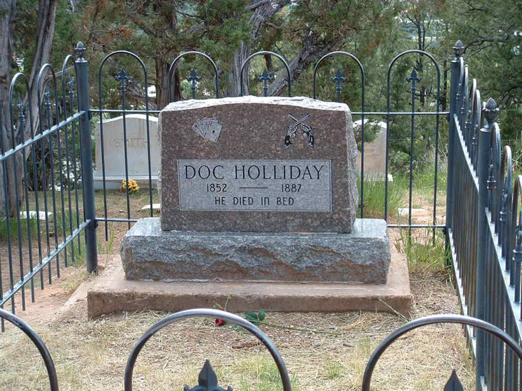
    Anyway, I got to the cemetery trailhead and parked the car. This was the right place. A sign pointed the way to the cemetery, up a steep trail. I found out later, no one knows exactly where Doc Holliday is buried. It's an unmarked grave somewhere in the cemetery. A sign explained with words to this effect: John Holliday arrived in Glenwood Springs in last stages of the disease know then as consumption. He worked in the gambling houses. People liked him. When he died, they passed the hat and collected enough money to bury him. A Midwestern gang threatened to steal the body, so Doc's employers hid him away for several years in the basement of a local house. When they felt it was safe, they buried him in an unmarked grave. I guess they wanted to make sure he stayed put. Years later, when he had become bigger than life because of his dealings with the Earps and the OK Corral shootout, a nice monument was carved and placed in the cemetery. It reads, "Doc Holliday, 1852 – 1887. He died in bed." A smaller headstone explains that this is not the actual burial site.
            Wait a minute, I’ve seen the movies. The first one was My Darling Clementine, starring Henry Fonda as Wyatt and Victor Mature as Holliday. In the big shoot out Doc is firing away from behind a rail fence when he gets shot and dies right in the middle of a coughing spell ...The End.  But in Tombstone, Doc dies moments after a poignant, deathbed visit from Wyatt Earp. The camera moves in for a close up. Holliday is weak. His eyes blood shot. There are beads of sweat on his brow and he is unable to feel his toes. He smiles and whispers his last words, “Well, I’ll be damned.” ... The End. 

Of course My Darling Clementine, got it all wrong, what do you expect it’s a movie. At least Tombstone is accurate in one respect, Doc Holliday, as the cemetery epitaph says, died in bed.

Q

Thursday, February 14, 2013

George Washington Gale Ferris, Jr.


This is the 154th anniversary of the invention of the Ferris Wheel, which became a major attraction at the Chicago World Columbian Exposition of 1893.
    The man who invented it grew up in Carson City. Ferris arrived in Nevada in 1864 at the age of five. His father, George Ferris Sr., was a horticulturalist who was responsible for much of the landscaping in Carson City in the 1870s, including the grounds of the State Capitol.
    The Ferris family lived in the Carson Valley for two years and then moved to a house on the southeast corner of Third and Division streets in Carson City. In 1875, George Ferris Jr. left Nevada to attend the California Military Academy in Oakland. In 1880, he received a degree in civil engineering and was hired by an architectural firm in New York City.
    After a few years, a Pittsburgh firm hired him and it was while working there that he designed the Ferris Wheel. It grew out of the desire to have some kind of structure that would be just as iconic as the Eiffel Tower. Apparently the erecting of the tower was somewhat of a thorn in the side of American engineers. The Americans wanted something grander, something that would say to the world that American engineering prowess was just as good as the French’s, maybe even better.
    The first impression of the fair’s steering committee was not favorable. They initially dismissed the design as being a “crackpot” idea. It was, “modeled on a bicycle wheel: in the pace of spokes to maintain the wheel’s shape and balance, it had heavy steel beams, the ‘forks’ in which the axle was set were two steel girder pyramids. The wheel was 264 feet high, the supporting towers were 140 feet high, and the axle – the largest piece of steel ever forged in the US – weighed 46 ½ tons. The wheel carried 36 elegantly outfitted passenger cars, each of which could fit 40 people sitting or 60 people standing. That's a maximum capacity of 2,160 people! The wheel was spun by either of two 1,000 horsepower steam engines, and stopped by an oversized air brake.”
Much to the committee’s surprise the wheel was proved to be safe.
     It was an immediate hit at the fair and in less than a half year it had carried 1.4 million passengers. In 1904, the wheel was moved to St. Louis for the Louisiana Purchase Exposition. Following the show, it was destroyed for scrap. However, the wheel outlived Ferris, who died in Pittsburgh in 1896 at the age of 37.

Q

Friday, January 18, 2013

Westward Ho!


It was bound to happen...In the late 18th century, this young nation wasn’t content to be confined to the boundaries of the original thirteen colonies, so some eighty years after the Pilgrims landed, exploration shifted into high gear and thus began what was termed “manifest destiny,” the expansion across the continent. Several trails were blazed. People packed up their belongings and headed west. The historic trails reached their peak between 1830 and 1870. During that time period upwards of two-thirds of a million pioneers and traders used them. It took the pioneers six months to do what we can do in a few days. And we do it free of all the hardships and in relative comfort. We have no rivers to ford, no Indians to fight, no disease to contend with, and no shortage of food and water to suffer through. Best of all, we don't have to walk most of the way.
   In addition to the pioneer trails, I’ve added four other trails: the two that were developed so that goods could be brought for trade to new settlements in the southwest, the route used by the Pony Express and finally the all important first transcontinental railroad route.

Lewis and Clark Trail 
”The Lewis and Clark Expedition of 1803-1806 was perhaps the most important in the history of American exploration. It opened up vast new territories to American knowledge. After the Louisiana Purchase, Meriwether Lewis and William Clark were sent to explore the new American territory. They sought a land route to the Pacific, and along the way they made many scientific observations, collected many specimens of flora, and studied the Indians.” 


The Oregon Trail  The first serious attempt by a group to emigrate west along the Oregon Trail took place in 1841. The trail ran from the Missouri River in Kansas City, across Nebraska and Wyoming, on to southern Idaho, and finally into Oregon. Here we have a bit of a puzzle. The map I looked at had it ending in Vancouver, but I have seen a sign in Seaside, OR on the coast west of Portland, which says that that was the end of the trail.  Finally according to Wikipedia the terminus is Oregon City. When asked the question, Where does the Oregon Trail begin and end? WikiAnswers had this to say:
    Well, that depends on how you look at it. Officially, according to an act of Congress, it begins in Independence, Missouri, and ends in Oregon City, Oregon. To the settlers, though, the trail to the Oregon Country was a five-month trip from their old home in the East to their new home in the West. It was different for every family. Some people got ready to leave the East, or "jump off" as they called it, in towns like St. Joseph or Council Bluffs, and others jumped off from their old homes in Illinois or Missouri and picked up the Oregon Trail in the countryside. Along the way, they could choose to take shortcuts or stick to the main trunk of the Trail, and the end of their journey didn't really come until they settled a claim somewhere in the vast Oregon Country.

The Mormon Trail  The trail began in Nauvoo, IL, the year was 1846. Harassment, antagonism, and persecution forced the Mormons out of Nauvoo. The trail’s route ran 256 miles across Iowa to the Missouri River and then 1032 miles across the Great Plains following pretty much the same path as the Oregon Trail until eastern Wyoming where the trail headed southwest to the Valley of the Great Salt Lake. Over a twenty year period, 70,000 Mormons traveled by wagons and handcarts along this route. 


The California Trail  The trail followed, generally speaking, the same course as the Oregon and Mormon Trails. Near American Falls, Idaho, it headed south across Nevada, over the Sierras and into the golden state.


The Santa Fe Trail   William Becknell was a trader who wanted to take his goods to Santa Fe to sell. He felt the new settlers in New Mexico, who were lacking essentials, would welcome his business, which turned out to be true.


The Old Spanish Trail  The trail was used as a trade route linking Santa Fe, New Mexico and Los Angeles. It had a brief, but active heyday between 1830 and 1848. Traders took goods west and returned with mules and horses.


The Pony Express  The Pony Express was a brave enterprise. It took a lot of guts for the young riders to brave the environment, the Indians, and the weather. It was a job filled with danger. An advertisement recruiting riders asked that recruits be expert riders, willing to risk their lives. "Salary, $25 a month and Orphans Preferred," read the handbills. From St. Joe to Sacramento in ten days was the promise, and they did it. Remarkable! It only lasted 18 months (April 1860 to October 1861) because by that time transcontinental telegraph lines stretched across the continent, and as a result the Pony Express was forced out of business.

Transcontinental Railroad  By 1869 the transcontinental railroad was completed, Leland Stanford pounded in the golden spike (supposedly) and travel over the various pioneer trails declined. I’ve read that old man Stanford tried three times to hit the spike and missed all three times. Finally a railroad employee did the deed and history was made at Promintory Point, north of Salt Lake City.


Saturday, December 15, 2012

Waterhole Ike, tale of a beer guzzler


Once upon a time there was a famous resident 
of Golconda, Nevada.  His name was “Waterhole Ike.”  He lived there in the 1970s.  Mark Cowley ran the local saloon called Waterhole  #1.  There was one customer who was regular as clockwork.  Every morning about 10:30 here he’d come for his bucket of beer.  There was one thing about the customer that was mighty peculiar; he was Cowley’s pig, named appropriately “Waterhole Ike.”  Cowley learned that big money could be made putting famous animals out to stud.  So he decided to form a syndicate, sell stocks and then watch the money roll in.  He read that the very same thing had been done when the champion racehorse, Secretariat, was sold to a syndicate.  Cowley began selling shares and soon the money was mounting up, so much so that Cowley figured he needed to open a bank account in Ike’s name.  The local bankers refused, because Waterhole Ike didn’t have a social security card.  Cowley got an application, gave Ike a last name, a father and mother, and a birth date (5/1/1974).  Cowley submitted the application, having signed for Ike and in no time at all Waterhole Ike had himself a Social Security number (530-80-4623) and later a proper bank account, so Cowley could deposit money for Ike’s retirement.  The $25 stud fees soon began rolling in.  The press got hold of this and soon Ike was in the national press.  Over several years Ike fell on hard times and his bank account started to shrink.  About that time Ike fathered nine little piglets.  Crowley went to the welfare office in Winnemucca.  He told them his friend with a proper social security card was out of work with nine children to support and long story short, Ike began receiving $600 a month and food stamps.  But Cowley never cashed the checks or used the stamps.   Cowley grew tired of the saloon business, so he sold it and moved away.  And what became of Waterhole Ike, a Golconda legend, he lived to a ripe old age, as far as pig life goes.  The End.

This is mostly fact believe it or not.  Sorry about the poor quality picture of Ike.  It’s the only one I could find.