Sunday, November 29, 2015

Mission San Francisco de Asis

Gaspar de Portola, on his second expedition along Alta California’s coast, made the first European discovery of San Francisco Bay in 1769.  Actually he stumbled on to it. Unlike other bays along the coast, the bay wasn’t easily recognizable from the sea, due to its landlocked nature. Portola’s intention was to find Monterey, but somehow he missed it and sailed right on by.  He continued on to what is now Pacifica where he anchored his ship. He formed a party of crewmembers and he and his men climbed to the summit of the coastal ridge, where they sighted the great bay. In a way, it was Spanish treasure seekers from the Philippines sailing the west coast of North America who were responsible for the bay’s name. In 1559, a Spanish galleon was shipwrecked at Pt. Reyes. The crew managed to survive and the captain named the site “Bay of San Francisco.” The name was later transferred to what we now know as San Francisco Bay.
    Upon receiving the news of Portola’s discovery, Spain immediately recognized the bay’s strategic importance and ordered the establishment of a presidio, pueblo and mission. Because supplies and manpower were scarce, the work had to be delayed.  Six years later the explorer Juan Bautista de Anza blazed an overland trail to Monterey. The Viceroy of New Spain, hoping to forestall the Russians and the English who were beginning to move south from the northlands immediately ordered Anza to lead settlers north to the bay. They successfully made the trek and as they stood atop a cliff overlooking what eventually would be known as the Golden Gate, the natural beauty impressed them. The group continued their search and soon came upon a lovely creek, which emptied into a lagoon.  This, it was decided, would make a perfect mission site. The location was named Arroyo de Nuestra Senora de los Delores.
    Seven years later in June of 1776, Father Francisco Palou, an assistant to Father Serra, celebrated Mass at the site, five days before the signing of the Declaration of Independence. The new mission was named San Francisco de Asis in honor of Saint Francis of Assisi. Later, it became popularly known as Mission Delores.
    Unfortunately, the padres discovered that the site was far too swampy, so they moved the mission to what was thought to be a better site, which is where it stands today. They immediately began a building program and by 1791, the construction on a permanent church was completed.
    In the 1860s a larger brick church was built adjacent to the mission. Indian neophytes built the mission so well that it withstood the forces of the 1906 earthquake, however the brick church was destroyed. In 1913, a new church was constructed next to the mission and in 1917 a careful restoration of the mission was started. The church was remodeled in 1926, with design elements inspired by San Diego’s 1915 Panama-California Exposition. Pope Pius XII elevated the church to a Minor Basilica in 1952.

   The mission was not very successful when it came to native conversions. Local Indians didn’t like the damp weather. A measles epidemic put 5,000 of them in their graves. Disease was so rampant that the padres had to establish a hospital site where the climate was drier. A site was chosen north of the bay in what would eventually be San Rafael. Later, when more Indians and settlers came into that area, the hospital became Mission San Rafael Arcangel.
    Mission Delores was in competition with the nearby pueblo, Yerba Buena, for space for agriculture, so the mission established a rancho (estancia) down the peninsula. The site was a Costanoan Indian village before it served the agricultural needs of the mission. The rancho is now known as the Sanchez Adobe. It is located in Linda Mar, just off Highway 1.
    When gold was discovered in California, everything changed for both the sleepy pueblo and the mission. Yerba Buena, the original settlement, grew from 900 to 20,000 practically overnight. It soon was chartered as San Francisco county and city. The Mexican government had seized the mission buildings and by the time they were turned back to the Catholic Church very little was left.
    Today, an elegantly designed church is all that is what remains of the mission. Its next-door neighbor, the Basilica, dwarfs it.
    Mission Delores has the distinction of being the oldest intact building in San Francisco and the oldest intact mission church in the chain with the original redwood logs supporting the roof still in place. Mass continues to be celebrated in its beautiful interior.


Note: Pope Pius XII elevated Mission Delores to ta status of Minor Basilica in 1952.  It was the first designation of a basilica west of the Mississippi and the fifth in the United States.  Today the large church is called "Mission Delores Basilica," while the adobe structure retains its original name.


Friday, November 27, 2015

Mission San Luis Obispo de Tolosa

Gaspar de Portola, Governor of Los Californias, and Father Juan Crespi attempted to reach Monterey Bay by land in 1769. Along the way, the party camped in a lovely valley where they were amazed to find so many bears. They gave it the nickname La Canada de los Osos (The Canyon of the Bears). Years later, when food supplies were running low, Father Serra remembered the valley and sent hunters there. The successful hunt and further investigation convinced Serra that the area would make the perfect site for a mission and so work on it began. In 1792, Serra christened the mission San Luis Obispo de Tolosa in honor of Saint Louise, Bishop of Toulouse, France. 
    The early years were not always peaceful for the mission. While many of the local Indians were friendly, there were a few were not.  On three occasions, they set fire to the mission’s thatched roof. In answer to this, the padres developed a red, fire-resistant, clay tile, which proved to be a good deterrent. The tiles were such a success that all the missions began using the new formula for roofing material.
    None of Alta California’s missions were ever fully self-sufficient; consequently they received some financial support from Spain, albeit modest. The Mexican War of Independence in 1810 changed all that. Gradually, over time, Spain sent fewer funds, which caused major financial problems for most of the missions. Spain also forced the missions to send food and clothing to the army. The demand was a heavy burden on Mission San Luis Obispo, but it was able to not only meet the demand, but also continue its building program. By 1820, the mission had finished the construction of its quadrangle. And then circumstances worsen.
    By 1835, Mexico had been an independent nation for fourteen years. During that time the Mexican government secularized Mission San Luis Obispo, which meant the padres no longer managed it. Pio Pico, Alta California’s governor, sold the mission's buildings, all except the church for $510. The buildings were then used for a variety of civic and military uses.
    During the Bear Flag Revolt, John C. Fremont and his "California Battalion" occupied the mission and used it as a base of operations. It was later used as the first courthouse and jail in San Luis Obispo County, California. The mission was eventually returned to the Catholic Church.
    In the early days of statehood, the citizens of San Luis Obispo lived in fear of the many bandits that roamed at will throughout the area. In 1853, the notorious bandit Joaquin Murietta, “the Robin Hood of El Dorado,” and his men terrorized the town, literally taking it over and occupying it for several days. They camped in the mission’s garden. Later that same year the newly formed California State Rangers brought about an end to Murietta’s gang.
   
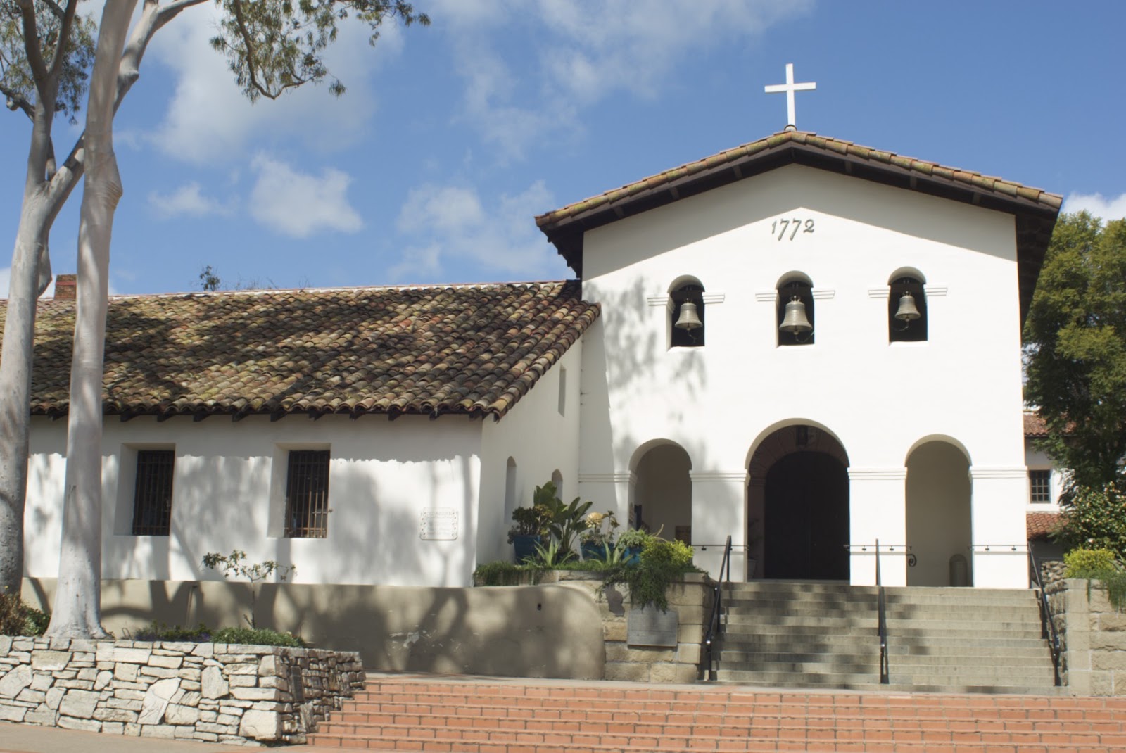
 The mission’s buildings have design features that are unique among the twenty-one missions. There are three bells hanging in three arched openings above the church entrance. The vestibule, sits at a right angle to the main part of the church (nave). It's almost equal in size and shape to the nave. The convento colonnade has square openings and round pillars, a style not used in any other mission.
    Even though Mission San Luis Obispo went through many changes during its history, it remained in its original location, unlike many of the other missions. Today, the mission is in the center of a thriving city that grew up around it and functions as a Roman Catholic parish church in the Diocese of Monterey. San Luis Obispo proudly calls itself, "The City with a Mission."

NOTE: Los Californias = Baja California & Alta California.  The convento is where the friars live.  Friars differ from monks in that friars are called to a life of poverty in service to a community, while monks cloister themselves away from society.  Friar is a corruption of the French word frere meaning brother.


The photographs below show places where a section of a wall has been purposely exposed to show the building materials. On the left is a portion of a wall and on the right is a section of an adobe wall.

Monday, October 26, 2015

Cave Lake

Nevada’s Cave Lake is a very popular state park for people who love outdoor recreation. The 32-acre reservoir sits at 7,300
feet and has an average depth of 25 feet and 60 feet at the deepest. The last time I was there it was in early March and the lake was still frozen over. I arrived too late to see the annual White Pine Fire and Ice Show, which features ice and snow sculpturing. But there were ice fishermen hard at work, plying the water for trout. I didn't see any of them catch any fish, but they seemed to be pretty content anyway. As of 2006, Cave Lake holds the record for the largest German brown trout, weighing more than twenty-seven pounds. If you like crayfish, fresh water cousins to lobsters, well there’s a large population of them that’s pretty easy to spot along the shoreline.
    Some people consider Cave Lake State Park to be the most beautifully situated parks in Nevada. Richard Moreno, author of Backyard Traveler says, “The dark emerald lake is situated in a scenic niche in the mountains, surrounded by forests of pinyon and juniper. Above the lake is a small yawning cave—the namesake of the lake—and ridges of rough, crumbling granite peaks weathered by countless centuries of icy winters and hot summers.”
    In 2012 Recreational Boating & Fishing Foundation, a national organization, invited Facebook subscribers to help determine the top eight natural "waterparks" or state parks, for boating and fishing in America. There were 24 nominees and after eight weeks of voting Cave Lake State Park wound up as one of the top eight for fishing, boating and family fun.
    There's a pretty good campground adjacent to the lake. It offers the usual camping sites. If you decide not to pitch a tent or park your RV, you could stay in one of the yurts. I just might do that some day.

Cave Lake State Park is located in White Pine County, Nevada 15 miles southeast of Ely.

Note: Nomads in the steppes (grassland plains) of Central Asia traditionally built yurts as dwellings. They were well insulated, weatherproofed and above all portable. The first written evidence of them dates back to 484 BC when the Scythians, a horse riding-nomadic nation used them. Yurts were designed in such a way that they could be dismantled and then loaded onto camel or yaks and transported to the next location. It took an experienced nomad about two hours to build one. The yurt at Cave Lake has a wood lattice frame, plywood floor and canvas wall and ceiling.